Saturday, November 27, 2010

From the Wintery Mountains to Warm Virginia

Hello world!

It has been a while since we've given you an update on our travels. Sorry about that.

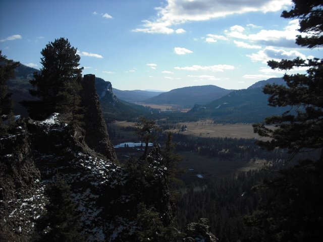
We had a busy couple of weeks travelling around the tremendous mountains of Colorado. After a friendly neighbor at the Great Sand Dunes campground help us jump-start the car (after too much party music blasting from our car with the engine off, apparently) we set out westward towards Durango. We got our first taste of alpine Rocky Mountain environs as we crossed over the freshly snow-covered mountains of the San Juan and Rio Grande national forests. Here, spectacular rock pinnacles erupt from mountainsides dotted with evergreens, and the mountains loom over verdant pastureland in the valleys.

We reached Durango in the evening and checked into a dirt-cheap hotel room, since it was way too cold to be camping. The next day (or what little sliver of it the daylight savings shift seems to leave for us) we explored the historic downtown district of Durango. Despite housing thoroughly modern stores, the downtown area retains the look and feel of its frontier-town ancestry.

The following day, we awoke to flurries of snow falling outside the hotel window. Trying to ignore the bad omens, we drove northward into the mountains, heading for Ouray. As we crested the first of several mountain passes, we could tell that the weather was worsening. The third (and final) mountain pass was also the highest, around 13,000 feet. We made it up the mountain by following a snow plow, but the way down the north slope was up to us. Hard blowing snow made it nearly impossible to see the winding road ahead, but we managed to remain on track by following the ruts made by a previous car. After a few scary hairpin turns, we inched our way down into Ouray. By this time, the sky was darkening and the snow was showing little sign of letting up. After talking to our Couchsurfing host, we decided that we couldn't make it to her house, which lay some distance down an unpaved road. So, we decided to check into another cheap motel, then relieve some of the day's stress at the newly founded Ouray Brewery.


This is what we drove through.


By the following morning, temperatures were rising, the snow was melting, and the roads were clear. We hopped in the car and drove northward towards Montrose, intending to reach Crested Butte that evening. East of Montrose, we noticed a sign for the Black Canyon of the Gunnison National Park. On a bit of a whim, we decided to check it out. Nothing could have prepared us for the stunning views which awaited. It's hard to tell exactly how deep this beautiful canyon is until you throw a snowball over the edge and watch it disappear from view long before it hits the bottom. We spent the entire afternoon exploring the many established viewpoints overlooking various sections of the canyon. As the sun dipped low, we decided to stay in the park's free (however snow-covered) campground, rather than continuing eastward. We set up camp, cooked dinner, and decided to head into Montrose to avoid the cold. After Christy washed our dinner dishes in a Target bathroom (she keeps it classy) we aimlessly wandered the gargantuan store, happy to be out of the cold wind.


Black Canyon of the Gunnison

The following morning, we drove to Crested Butte. Crested Butte is an unbelievably cute little ski town nestled between high mountains. We wandered the downtown area, with roads still blanketed in the previous night's snow, until late afternoon. After our Couchsurfing host, Sunny, got home from teaching preschool, we headed over to her house. We were ecstatic to find a warm cottage and a soft bed waiting for us. The next day, we did a but more wandering around town. After climbing a small hill which gave us a nice view of snow-covered Crested Butte, we heading down into the village. Christy found a fantastic winter coat in a thrift store, something she had been needing for a while. Later, we stroll for a couple of miles along the Lower Loop trail, a public multi-use trail built primarily on land reclaimed from a closed heavily-polluted coal mine (surprise, surprise). Thankfully, the land is now put to much better use by dog-walkers and mountain bikers.

Crested Butte

Frozen pond in the reclaimed mining area


Following our second night in Crested Butte, we drove westward to Colorado Springs. The landscape rapidly changed as we drove towards the plains of eastern Colorado. Exiting the high mountains, we headed through South Park (yes, the South Park), a vast expanse of gently-rolling grassland, used primarily for pasture. It's the perfect place for an imaginary town. As the sun dropped behind our car, it illuminated the red-orange rocks of the "front range". We soon arrived at our hosts', Tom and Mary, house. Tom was Christy's father's college roommate, and he and his wife Mary graciously agreed to host us for a few days.

Over the next few days, Mary and Tom led us on several hikes through Garden of the Gods park, an area of of towering red sandstone formations directly behind their neighborhood. We also did a bit of exploring in the city. First, we looked around Old Colorado City, which was the hard-living, seedy counterpart of refined Colorado Springs in the 19th century. Today, Colorado City is the hip shopping and entertainment district of Colorado Springs. We checked out a world of miniature sculptures at Magic Town before heading towards downtown Colorado Springs. On Tejos Ave., the Springs' main downtown strip, we found an expansive costume shop. Apparently Christy looks awesome in a fake beard (a la The Soggy Bottom Boys).


A very sunny day at Garden of the Gods Park

After spending a less-than-restful night dozing on the couch in the Colorado Springs Municipal Airport, we boarded a jet at 6 AM and flew home to Virginia on Monday the 22nd. Until January 5th, we'll be enjoying a relaxing holiday season with our families. The Subaru awaits us in Colorado Springs when we return.

Sunday, November 14, 2010

Bandelier National Monument, Santa Fe, Taos, and Great Sand Dunes National Park

Christy here, writing from Durango, Colorado. This is the first time we've had internet and electricity for a little while, so it's time for an update!

After leaving Albuquerque, we went north to Santa Fe, where we camped one night in a state park on the side of a mountain. It was quite cold, but we got a fire roaring and made friends with a fellow transient/camper from Chicago. The next night, we decided to save a few bucks and camp in a free National Forest campground on top of one of the highest mountains in the area. We were above 12,000 feet, and that was probably the coldest I've ever been in my entire life. In retrospect, I was experiencing symptoms of Acute Mountain Sickness, but I'm feeling much better now. In the morning, we awoke to the sounds of ice hitting the tent, packed up as quickly as possible in the snow, and got off that mountain.

From there, we headed to Bandelier National Monument for a visit, which is an old cliff dwelling site in a canyon a little ways outside Santa Fe. Near that area, a long time ago, there were some massive volcanic eruptions that covered many hundreds of miles hundreds of feet deep with ash, which eventually compressed to form this soft type of stone called tuff. This tuff eventually was worn away into a canyon, and in those canyon walls, people were able to scratch out rooms on the side of the cliffs. They also built stone houses and kivas (ceremonial rooms dugout into the earth) in the canyon bottom. People lived here around 600 years ago, and their descendants still live near that area.

A restored kiva.

Remains of the circular community in the canyon.

The view from one of the cliff dwellings.

Here you can see rooms built on the side of the 
cliff, as well as entrances into some of the cliff rooms.


After Santa Fe, we headed further north to Taos, New Mexico. This is a pretty hip, artsy town that caters to ski enthusiasts. It was kind of an odd time to visit because it's too cold to mountain bike and too warm to ski. We stayed at a hostel so we didn't have to camp in the frost, and there found a ton of folks in town hoping to get a job in the ski valley for the season. Near Taos is the second highest bridge in America over the Rio Grande. The view is pretty amazing, and it's a little scary when a car goes over the bridge and everything shakes.
View from the bridge.

After Taos, we headed further north into Colorado! We camped at the Great Sand Dunes National Park and Preserve, which is a really interesting area. Land is very flat and fairly empty for a really long time, then the rockies just shoot up out of nowhere, high into the sky. Then you get a little closer, and find this almost perfectly circular area of massive sand dunes right up next to the mountains. The sand comes from far away and is carried there by two streams. Some of the dunes are over 700 feet high, and form such a beautiful and unique landscape. We spent one day hiking up through them. Some of the sand formed different ripples and patterns, some of it was hard as a rock, and some was so soft we sank right in. There were all kinds of different shadows, and fairly treacherous-looking dropoffs and peaks. Here are a few pictures.

Flat grassland, sand dunes, and rockies.

In the dunes!

Christy in the dunes.

The center of the dune basin, from on top of a really huge one.

Beautiful shadows!

Up on top.

That's me sitting up there.

It was quite cold camping at the dunes, so cold, in fact, that 1. my toothbrush was a frozen block, 2. Connor's contact lenses were frozen in little circles of saline, 3. our breath at night condensed inside the tent and froze, so the inside of the tent was covered in frost in the morning, and 4. our water bag froze almost completely solid. We were pretty excited to find out that there are hot springs in the area! And, thankfully, a modest community center had built a pool and only charged 8 bucks to use it and the hot tub, which is way cheap compared to most of the fancy resorts that pop up around hot springs. It was wonderful, and the pool had a beautiful view of the mountains.

Because of this cold, we got a cheap motel room (for the first time on our trip!) in Durango for two nights. We just spent today exploring town a little bit, and we're planning on heading a little further north into the mountains tomorrow. We'll be staying with our first couchsurfing host outside a tiny town called Ridgway, which is surrounded by mountains. We hope to get some good hiking in. We might not have internet for a while, so we'll be in touch when we can!


This is one of the scenic overlooks on our drive from the Great Sand Dunes to Durango.

Sunday, November 7, 2010

Lots to catch up on

We've been so busy hightailin' it across the country, we haven't had time to write a post in forever! So, here's our update for y'all.

After we left Memphis, we spent a little bit of time exploring Arkansas. We spent one night in Little Rock, which seems like a pretty happenin' little city. We camped on the Maumelle River, near where it empties into the Arkansas River, and had a nice kayak ride that afternoon around an island. We narrowly escaped a frustrated blue heron; I didn't even know they lived that far west. Since there was a burn ban in effect due to dry weather, we couldn't have a campfire, so we spent our evening downtown! We found an awesome brewhouse and camped out, enjoying peoplewatching and listening to the guitarist singing covers

The next day we packed up again and headed westward to Hot Springs, Arkansas. This was a really neat town. Half of downtown is a National Park, and consists of all the old bathhouse buildings from the turn of last century. During this "Golden Age of Bathing," it was fashionable for wealthy Easterners (including lots of New York gangsters) to recuperate and relax in the mineral-rich hot springs waters, and be pampered in the elaborate bathhouses. We camped in the National Park campground for a few nights, and got hit by such a big storm it made headlines across the country. There was hail, heavy rain, and scary winds. We miraculously got out of there with our tent intact, and only mildly damp sleeping bags.

After exploring Hot Springs, we headed northward to our next farm! We spent a week at Ozark Alternatives, also known as Great Spirit Farm and Orchard, in Fayetteville, Arkansas. There we were hosted by Paul Chapracki and his partner Amanda, and their two sons, Oliver (6 y.o) and Isaac (3 y.o). This was a 25-acre farm community, nestled between housing developments on all sides. Originally it was a 100-acre family farm, and slowly got chiseled down to its present size. Also on the property are about 20 small houses that are rented out, so there's quite a tight-knit little community there.

Our main project during that week was to help build a greenhouse out of recycled materials and straw bales. We spent an afternoon helping deconstruct a Habitat for Humanity house, in order to get some building  materials from there. Those materials were turned right around and used for building the greenhouse, along with a bunch of old windows. We learned how to build walls with straw bales, and how to stucco with a cement mixture. The farm regularly hosts workshops so community folks can get involved and learn about projects like this, so last weekend, about ten people showed up to help and learn as well. It was really encouraging to see that kind of enthusiasm; a lot of the people there had plans to try something like that out as well. The Chaprackis plan for the greenhouse is to start veggie plants early in the springs, some of which they will sell, and some of which they will plant for themselves.

Besides working on the greenhouse, we spent some time doing garden work, including harvesting radishes, tomatoes, and Jerusalem artichokes. We also planted radishes and leeks, weeded, and watered. They sell their produce through a local cooperative grocery store, and it was really encouraging to see how that was working for them. We also spent a lot of time playing with the kids, including going trick-or-treating with Batman and Robin.

Here are a few pictures from the farm.

Connor and Oliver planting leeks.

Planting leeks with the boys.

Cleaning out the pepper patch for winter.


Denailing plywood.

Greenhouse work site.

Building the East wall!

Working on the West wall.


Learning to stucco.


Stucco-ing.

So, after working there for a week, we got the urge for going' again, and drove our longest day of driving yet. We spent about 9 hours in the car, driving through Oklahoma and into the Texas panhandle. Our destination was Palo Duro Canyon State Park, about 30 minutes south of Amarillo. Palo Duro Canyon is the second largest in the country, and was Christy's first canyon! We got there pretty late at night and camped right outside the park (for free!). We cooked dinner on the hood of the car, and listened to the coyotes in the distance. After Christy fell asleep, Connor heard one explore the campsite in the middle of the night, and saw its shadow pass by the tent! I'm glad I wasn't awake to see that. The next day we went down into the canyon, and camped at the bottom. We spent the afternoon hiking a 6-mile trail through the bottom of the canyon, up to a few of the geological formations called Castle Rock and the Lighthouse. The colors and textures and shapes were all so beautiful and interesting to see for the first time.

 
Capital Rock

In the canyon.

Castle Rock.

Lighthouse Rock

Palo Duro Canyon.

After our hike.

The next day we hit the road again, destination Albuquerque, New Mexico. But along the way, we stopped at the Cadillac Ranch, near Amarillo. It's an art installation on the side of old Route 66 from the 70s sometime. Now everyone pulls over to spraypaint on it. We had to leave our marks.

Cadillacs

Making my mark.

Christy's contribution.


In Albuquerque, we visited Connor's cousin for a few days. We spent an afternoon exploring Old Town Plaza, which is all old Spanish adobe buildings and Pueblo jewelry shops. It was really interesting to see that architecture and history still in the middle of this city. We also went to the Albuquerque Museum of Art and History, which had a couple modern art exhibits, and a four-century history lesson about the city. Yesterday was Christy's 23rd birthday, so we spent the day getting excited about some anthropology! We visited Petroglyph National Monument, which is just outside the city. It preserves thousands of carvings in volcanic boulders. Some carvings were made as long as 2000 years ago; some were made as recent as the past few hundred years. There are tons of different symbols and pictures, lots of swirls, birds, people, faces, handprints, and other animals. There was even one of Kokopelli! It was very, very cool to see, and Christy was especially happy to find out that the first anthropologist to do research on all the carvings was a woman in the 1930s. What a badass.

Albuquerque

Old Town

Old Spanish church

Chilis drying

Petroglyphs!


So, that brings us to here and now. We're planning on leaving Albuquerque this afternoon, and headed north towards Santa Fe. We'll be camping in the Santa Fe National Forest for the next few days, using that as a home base to explore a few of the national monuments and parks around that area. The potential plan for now is to make a little loop in northern New Mexico and southern Colorado in the next couple weeks, then fly home for Thanksgiving and Christmas! So, we'll be home on the East Coast from November 22nd through January 5th, then flying back out to Colorado to continue our trip. So, we'll see (almost) everyone soon!

Friday, October 22, 2010

Chattanooga and Memphis

So, we've yet to tell y'all about spending a few days in Chattanooga and Memphis.

We stayed in a State Park campground about an hour outside of Chattanooga after leaving Doubletree Farm. After setting up camp and getting groceries, we noticed a huge smoke cloud coming off the side of the mountain next to our campsite. As the night progressed, we could see the blaze of a growing forest fire through the woods.  Though the park ranger assured us that fires always move upward, Christy was a little nervous going to sleep that night. From inside our tent, we could hear the trees falling and bulldozers working on clearing a firebreak. By morning, things had calmed down, but we could still see a big burnt clearing on the side of the mountain. Such excitement!

As for the city itself, it seems like a pretty cool town. We enjoyed hanging out in the North Shore district, which has it's share of cutesy stores and coffee shops. Across a pedestrian bridge over the huge Tennessee River, you come upon the museum area. We spent our afternoon at the world-class Tennessee Aquarium, which blew our minds. Highlights: They had a really great jellyfish and seahorse exhibits, we got to touch stingrays, and we enjoyed learning about cuttlefish. Cuttlefish are SO smart, they make facial expressions with their tentacles, and change colors to express themselves, and can make eye contact through the glass. They were so curious,  coming up to the glass to look at each new aquarium visitor. That was definitely one of the coolest parts of our visit. The aquarium also did a great job with displaying different river systems of the world, and had an impressive array of really interesting organisms.

Also at the aquarium, we watched an IMAX 3D movie about the Hubble space telescope. It was pretty cool; both of us got to learn about our favorite topics that day.

As for Memphis, we were a little less impressed. We were hoping to find a city still alive with a vibrant music scene, but instead, found the city celebrating it's musical past. As far as we can tell, there is virtually no youth culture here, and the only real places to visit are Beale Street (a 24/7 party zone) and Graceland (which charges a ridiculous admission). But, let's stay positive. We stayed in a really nice hostel in a decent area, and enjoyed a long walk through downtown one day. Yesterday, we went to the Memphis Zoo and had a great time learning about all the animals. We were happy to see that the animals were well taken care of and stimulated. Highlights: a 16-foot boa constrictor, very active bonobo community, acrobatic gibbons, really interesting gorilla interactions, and a sea lion show.

So, now we're headed further west to Little Rock, Arkansas. Our plan is to explore that area for the next day or so, then check out Hot Springs National Park, then go to our next farm, which is in Fayetteville, AR.


The scenic Maggie Valley, between Asheville and Chattanooga,


In the butterfly house & hatchery at the Tennessee Aquarium.


Sea nettles.


Some kind of spider crab, over two feet wide!